


crépy en valois

fitz2014
User
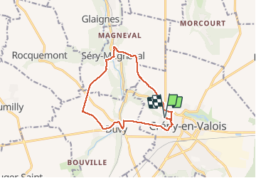

Length
12 km

Max alt
119 m

Uphill gradient
158 m
Km-Effort
14.1 km

Min alt
60 m

Downhill gradient
152 m
Boucle
Yes
Creation date :
2018-08-18 15:18:54.495
Updated on :
2018-08-18 18:19:36.427
2h59
Difficulty : Easy

FREE GPS app for hiking
 SityTrail
IGN / Geographical institutes
SityTrail Plus
The world is yours!
About
Trail Walking of 12 km to be discovered at Hauts-de-France, Oise, Crépy-en-Valois. This trail is proposed by fitz2014.
Photos


Positioning
Country:
France
Region :
Hauts-de-France
Department/Province :
Oise
Municipality :
Crépy-en-Valois
Location:
Unknown
Start:(Dec)
Start:(UTM)
491199 ; 5453996 (31U) N.
Comments