


Tuc du Maubermé

petit-pied
User
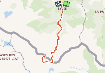

Length
24 km

Max alt
2852 m

Uphill gradient
1946 m
Km-Effort
49 km

Min alt
928 m

Downhill gradient
1945 m
Boucle
Yes
Creation date :
2018-08-19 05:21:37.284
Updated on :
2018-08-19 19:15:40.525
8h04
Difficulty : Difficult

FREE GPS app for hiking
 SityTrail
IGN / Geographical institutes
SityTrail Plus
The world is yours!
About
Trail Walking of 24 km to be discovered at Occitania, Ariège, Sentein. This trail is proposed by petit-pied.
Positioning
Country:
France
Region :
Occitania
Department/Province :
Ariège
Municipality :
Sentein
Location:
Unknown
Start:(Dec)
Start:(UTM)
331453 ; 4744522 (31T) N.
Comments