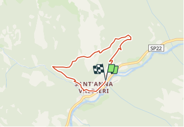
Trail Walking Valdieri - 11.16 - Photo
 jlrayon
jlrayon

User

© OpenStreetMap contributors
Length
Length
3.1 km
Max alt
Max alt
1239 m
Uphill gradient
Uphill gradient
258 m
Km-Effort
Km-Effort  
6.5 km
Min alt
Min alt
970 m
Downhill gradient
Downhill gradient
255 m
Boucle
Boucle
Yes
Creation date :
2018-08-23 08:03:39.491
Updated on :
2018-08-23 08:07:43.081

(0 Reviews)

Walking
Walking
1h17
Difficulty : Easy

Scan this QR Code to open this trail in the SityTrail application

FREE GPS app for hiking

Logo SityTrail SityTrail

IGN / Geographical institutes

Download SityTrail from the App Store Download SityTrail from Google Play

Logo SityTrail SityTrail Plus

The world is yours!

Download SityTrail from the App Store Download SityTrail from Google Play Download SityTrail on Huawei AppGallery

About

Trail Walking of 3.1 km to be discovered at Piemont, Cuneo, Valdieri. This trail is proposed by jlrayon.

Description

Itinerario 11.16

Elevation profile

Points of interest

Point of interest Valdieri - Tetti Bariau - Photo
jlrayon
VALDIERI 
Point of interest Valdieri - Tetti Bartola - Photo
jlrayon
VALDIERI 
Point of interest Valdieri - Sant'Anna di Valdieri - Photo
jlrayon

Positioning

Country:
Italy
Region :
Piemont
Department/Province :
Cuneo
Municipality :
Valdieri
Location:
Unknown
Start:(UTM)
366178 ; 4900465 (32T) N.


Close
My subscriptions