


Py J104

Airelle
User
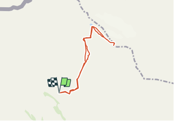

Length
7.3 km

Max alt
3317 m

Uphill gradient
1114 m
Km-Effort
22 km

Min alt
2189 m

Downhill gradient
1116 m
Boucle
Yes
Creation date :
2018-08-25 07:10:09.661
Updated on :
2018-08-25 07:13:39.155
3h22
Difficulty : Difficult

FREE GPS app for hiking
 SityTrail
IGN / Geographical institutes
SityTrail Plus
The world is yours!
About
Trail Walking of 7.3 km to be discovered at Aragon, Huesca, Fanlo. This trail is proposed by Airelle.
Positioning
Country:
Spain
Region :
Aragon
Department/Province :
Huesca
Municipality :
Fanlo
Location:
Unknown
Start:(Dec)
Start:(UTM)
255379 ; 4727732 (31T) N.
Comments