


Autopedestres : Beckerich

Visit Luxembourg
Randonnées de Visit Luxembourg. GUIDE+
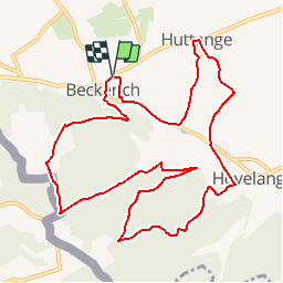

Length
11.6 km

Max alt
407 m

Uphill gradient
297 m
Km-Effort
15.5 km

Min alt
275 m

Downhill gradient
298 m
Boucle
Yes
Creation date :
2014-12-10 00:00:00.0
Updated on :
2014-12-10 00:00:00.0
--
Difficulty : Unknown

FREE GPS app for hiking
 SityTrail
IGN / Geographical institutes
SityTrail Plus
The world is yours!
About
Trail Walking of 11.6 km to be discovered at Unknown, Canton Redange, Beckerich. This trail is proposed by Visit Luxembourg.
Description
Fermé pour travaux jusque fin novembre 2012


Positioning
Country:
Luxembourg
Region :
Unknown
Department/Province :
Canton Redange
Municipality :
Beckerich
Location:
Unknown
Start:(Dec)
Start:(UTM)
707873 ; 5512821 (31U) N.
Comments