


Trace-pour-anne-4

anniston
User
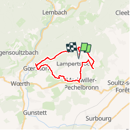

Length
21 km

Max alt
349 m

Uphill gradient
406 m
Km-Effort
26 km

Min alt
155 m

Downhill gradient
404 m
Boucle
Yes
Creation date :
2018-08-30 10:22:34.973
Updated on :
2018-08-30 13:19:05.81
--
Difficulty : Very easy

FREE GPS app for hiking
 SityTrail
IGN / Geographical institutes
SityTrail Plus
The world is yours!
About
Trail Coupling of 21 km to be discovered at Grand Est, Bas-Rhin, Lampertsloch. This trail is proposed by anniston.
Positioning
Country:
France
Region :
Grand Est
Department/Province :
Bas-Rhin
Municipality :
Lampertsloch
Location:
Unknown
Start:(Dec)
Start:(UTM)
413840 ; 5423876 (32U) N.
Comments