


Autopedestres : Clervaux

Visit Luxembourg
Randonnées de Visit Luxembourg. GUIDE+
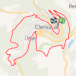

Length
6.8 km

Max alt
463 m

Uphill gradient
253 m
Km-Effort
10.2 km

Min alt
342 m

Downhill gradient
250 m
Boucle
Yes
Creation date :
2014-12-10 00:00:00.0
Updated on :
2014-12-10 00:00:00.0
--
Difficulty : Unknown

FREE GPS app for hiking
 SityTrail
IGN / Geographical institutes
SityTrail Plus
The world is yours!
About
Trail Walking of 6.8 km to be discovered at Unknown, Canton Clervaux, Clervaux. This trail is proposed by Visit Luxembourg.


Positioning
Country:
Luxembourg
Region :
Unknown
Department/Province :
Canton Clervaux
Municipality :
Clervaux
Location:
Unknown
Start:(Dec)
Start:(UTM)
287471 ; 5548938 (32U) N.
Comments
Une erreur de parcours après le cimetière, impossible de prendre le sentier au niveau des tables de pique-nique, je propose de continuer sur la route et de prendre directement sur la droite pour rattraper le tracé Et au niveau du bassin d’épuration, passer par les champs sur 20m sur votre gauche et hop retour sur le tracé