


Autopedestres : Kautenbach

Visit Luxembourg
Randonnées de Visit Luxembourg. GUIDE+
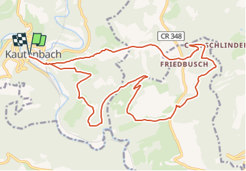

Length
12 km

Max alt
476 m

Uphill gradient
420 m
Km-Effort
17.6 km

Min alt
250 m

Downhill gradient
420 m
Boucle
Yes
Creation date :
2014-12-10 00:00:00.0
Updated on :
2014-12-10 00:00:00.0
--
Difficulty : Unknown

FREE GPS app for hiking
 SityTrail
IGN / Geographical institutes
SityTrail Plus
The world is yours!
About
Trail Walking of 12 km to be discovered at Unknown, Canton Wiltz, Kiischpelt. This trail is proposed by Visit Luxembourg.


Positioning
Country:
Luxembourg
Region :
Unknown
Department/Province :
Canton Wiltz
Municipality :
Kiischpelt
Location:
Unknown
Start:(Dec)
Start:(UTM)
286044 ; 5537605 (32U) N.
Comments
En 2025, ce parcours n'est plus balisé, remplacé par l'Eislek-pad de Kautenbach (avis au départ).