Autopedestres : Reimberg 2

Visit Luxembourg
Randonnées de Visit Luxembourg. GUIDE+
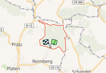

Length
5.1 km

Max alt
382 m

Uphill gradient
103 m
Km-Effort
6.4 km

Min alt
321 m

Downhill gradient
104 m
Boucle
Yes
Creation date :
2014-12-10 00:00:00.0
Updated on :
2014-12-10 00:00:00.0
--
Difficulty : Unknown

FREE GPS app for hiking
 SityTrail
IGN / Geographical institutes
SityTrail Plus
The world is yours!
About
Trail Walking of 5.1 km to be discovered at Unknown, Canton Redange, Préizerdaul. This trail is proposed by Visit Luxembourg.


Positioning
Country:
Luxembourg
Region :
Unknown
Department/Province :
Canton Redange
Municipality :
Préizerdaul
Location:
Unknown
Start:(Dec)
Start:(UTM)
712759 ; 5520682 (31U) N.
Comments