


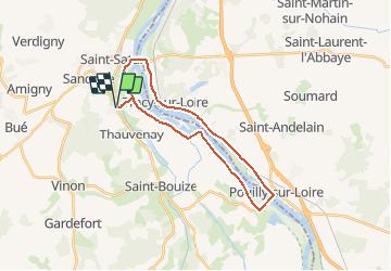
Sancerre - Pouilly
© OpenStreetMap contributors


4h01
Difficulty : Very difficult


Length
24 km
Max alt
192 m
Uphill gradient
333 m
Km-Effort
29 km
Min alt
141 m
Downhill gradient
333 m
Boucle
Yes
Creation date :
2018-09-09 09:11:28.739
Updated on :
2018-09-09 09:20:16.426
4h01
Difficulty : Very difficult
FREE GPS app for hiking
 SityTrail
IGN / Geographical institutes
SityTrail Plus
The world is yours!
About
Trail Mountain bike of 24 km to be discovered at Centre-Loire Valley, Cher, Ménétréol-sous-Sancerre. This trail is proposed by jean.marie.litzler@gmail.com.
Positioning
Country:
France
Region :
Centre-Loire Valley
Department/Province :
Cher
Municipality :
Ménétréol-sous-Sancerre
Location:
Unknown
Start:(Dec)
Start:(UTM)
489211 ; 5240477 (31T) N.
Comments