


Autopedestres : Tadler

Visit Luxembourg
Randonnées de Visit Luxembourg. GUIDE+
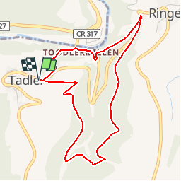

Length
4.6 km

Max alt
406 m

Uphill gradient
166 m
Km-Effort
6.8 km

Min alt
255 m

Downhill gradient
167 m
Boucle
Yes
Creation date :
2014-12-10 00:00:00.0
Updated on :
2014-12-10 00:00:00.0
--
Difficulty : Unknown

FREE GPS app for hiking
 SityTrail
IGN / Geographical institutes
SityTrail Plus
The world is yours!
About
Trail Walking of 4.6 km to be discovered at Unknown, Canton Wiltz, Esch-sur-Sûre. This trail is proposed by Visit Luxembourg.


Positioning
Country:
Luxembourg
Region :
Unknown
Department/Province :
Canton Wiltz
Municipality :
Esch-sur-Sûre
Location:
Unknown
Start:(Dec)
Start:(UTM)
715033 ; 5532987 (31U) N.
Comments