


Charleval - chaine des Côtes - Mont Trésor

mhetpierre
User
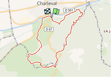

Length
10.6 km

Max alt
389 m

Uphill gradient
347 m
Km-Effort
15.2 km

Min alt
165 m

Downhill gradient
352 m
Boucle
Yes
Creation date :
2018-09-11 07:54:23.832
Updated on :
2018-09-11 18:17:03.19
3h46
Difficulty : Medium

FREE GPS app for hiking
 SityTrail
IGN / Geographical institutes
SityTrail Plus
The world is yours!
About
Trail Walking of 10.6 km to be discovered at Provence-Alpes-Côte d'Azur, Bouches-du-Rhône, Charleval. This trail is proposed by mhetpierre.
Positioning
Country:
France
Region :
Provence-Alpes-Côte d'Azur
Department/Province :
Bouches-du-Rhône
Municipality :
Charleval
Location:
Unknown
Start:(Dec)
Start:(UTM)
681094 ; 4842545 (31T) N.
Comments