


Sentiers_GR : GR-570

Visit Luxembourg
Randonnées de Visit Luxembourg. GUIDE+
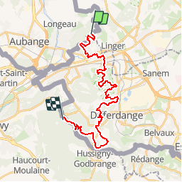

Length
25 km

Max alt
433 m

Uphill gradient
561 m
Km-Effort
33 km

Min alt
269 m

Downhill gradient
618 m
Boucle
No
Creation date :
2014-12-10 00:00:00.0
Updated on :
2014-12-10 00:00:00.0
--
Difficulty : Unknown

FREE GPS app for hiking
 SityTrail
IGN / Geographical institutes
SityTrail Plus
The world is yours!
About
Trail Walking of 25 km to be discovered at Wallonia, Luxembourg, Aubange. This trail is proposed by Visit Luxembourg.
Positioning
Country:
Belgium
Region :
Wallonia
Department/Province :
Luxembourg
Municipality :
Aubange
Location:
Athus
Start:(Dec)
Start:(UTM)
707106 ; 5495013 (31U) N.
Comments