


9162798-Mont Beuvray 06.46

togolo28
User
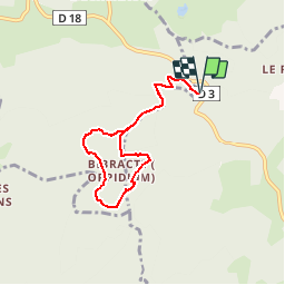

Length
6.5 km

Max alt
826 m

Uphill gradient
216 m
Km-Effort
9.3 km

Min alt
611 m

Downhill gradient
217 m
Boucle
Yes
Creation date :
2018-09-26 15:37:51.538
Updated on :
2018-09-26 15:38:46.458
1h57
Difficulty : Easy

FREE GPS app for hiking
 SityTrail
IGN / Geographical institutes
SityTrail Plus
The world is yours!
About
Trail Walking of 6.5 km to be discovered at Bourgogne-Franche-Comté, Nièvre, Glux-en-Glenne. This trail is proposed by togolo28.
Positioning
Country:
France
Region :
Bourgogne-Franche-Comté
Department/Province :
Nièvre
Municipality :
Glux-en-Glenne
Location:
Unknown
Start:(Dec)
Start:(UTM)
579809 ; 5198143 (31T) N.
Comments