


Crêt de Chalam depuis L'Embossieux

drarep
User
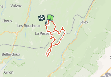

Length
25 km

Max alt
1522 m

Uphill gradient
898 m
Km-Effort
37 km

Min alt
1118 m

Downhill gradient
896 m
Boucle
Yes
Creation date :
2018-10-02 17:06:44.751
Updated on :
2018-11-26 20:32:42.065
3h35
Difficulty : Medium

FREE GPS app for hiking
 SityTrail
IGN / Geographical institutes
SityTrail Plus
The world is yours!
About
Trail Walking of 25 km to be discovered at Bourgogne-Franche-Comté, Jura, La Pesse. This trail is proposed by drarep.
Photos

Positioning
Country:
France
Region :
Bourgogne-Franche-Comté
Department/Province :
Jura
Municipality :
La Pesse
Location:
Unknown
Start:(Dec)
Start:(UTM)
719992 ; 5131147 (31T) N.
Comments