


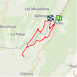
Lélex-Lélex Crêt de Chalam par la borne aux Lions

drarep
User

Length
25 km

Max alt
1524 m

Uphill gradient
1052 m
Km-Effort
39 km

Min alt
849 m

Downhill gradient
1050 m
Boucle
Yes
Creation date :
2018-10-02 19:00:42.0
Updated on :
2018-11-02 19:24:27.382
6h45
Difficulty : Difficult

FREE GPS app for hiking
 SityTrail
IGN / Geographical institutes
SityTrail Plus
The world is yours!
About
Trail Walking of 25 km to be discovered at Auvergne-Rhône-Alpes, Ain, Lélex. This trail is proposed by drarep.
Positioning
Country:
France
Region :
Auvergne-Rhône-Alpes
Department/Province :
Ain
Municipality :
Lélex
Location:
Unknown
Start:(Dec)
Start:(UTM)
725790 ; 5131522 (31T) N.
Comments