


2018-10-07 Marche Longemer lac de lispach Champis

holtzv
User GUIDE
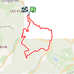

Length
14.9 km

Max alt
1201 m

Uphill gradient
722 m
Km-Effort
25 km

Min alt
745 m

Downhill gradient
718 m
Boucle
Yes
Creation date :
2018-10-07 09:09:59.29
Updated on :
2018-10-07 13:47:08.826
3h57
Difficulty : Very easy

FREE GPS app for hiking
 SityTrail
IGN / Geographical institutes
SityTrail Plus
The world is yours!
About
Trail Walking of 14.9 km to be discovered at Grand Est, Vosges, Xonrupt-Longemer. This trail is proposed by holtzv.
Positioning
Country:
France
Region :
Grand Est
Department/Province :
Vosges
Municipality :
Xonrupt-Longemer
Location:
Unknown
Start:(Dec)
Start:(UTM)
347220 ; 5325754 (32U) N.
Comments