


ttvexinbray

olivieraron
User
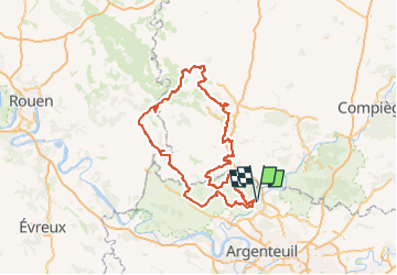

Length
250 km

Max alt
229 m

Uphill gradient
3006 m
Km-Effort
290 km

Min alt
23 m

Downhill gradient
3006 m
Boucle
Yes
Creation date :
2018-10-11 10:16:41.256
Updated on :
2018-10-11 10:41:46.005

FREE GPS app for hiking
 SityTrail
IGN / Geographical institutes
SityTrail Plus
The world is yours!
About
Trail of 250 km to be discovered at Ile-de-France, Val-d'Oise, L'Isle-Adam. This trail is proposed by olivieraron.
Positioning
Country:
France
Region :
Ile-de-France
Department/Province :
Val-d'Oise
Municipality :
L'Isle-Adam
Location:
Unknown
Start:(Dec)
Start:(UTM)
443399 ; 5440045 (31U) N.
Comments