


St Chamas - sentier du patrimoine

mhetpierre
User

Length
12.1 km

Max alt
111 m

Uphill gradient
216 m
Km-Effort
15 km

Min alt
-2 m

Downhill gradient
216 m
Boucle
Yes
Creation date :
2018-10-12 08:37:33.954
Updated on :
2018-10-14 17:05:33.97
4h25
Difficulty : Easy

FREE GPS app for hiking
 SityTrail
IGN / Geographical institutes
SityTrail Plus
The world is yours!
About
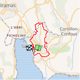
Trail Walking of 12.1 km to be discovered at Provence-Alpes-Côte d'Azur, Bouches-du-Rhône, Berre-l'Étang. This trail is proposed by mhetpierre.
Positioning
Country:
France
Region :
Provence-Alpes-Côte d'Azur
Department/Province :
Bouches-du-Rhône
Municipality :
Berre-l'Étang
Location:
Unknown
Start:(Dec)
Start:(UTM)
664269 ; 4823134 (31T) N.
Comments
Belle rando, très variee, merci à l'auteur de ce circuit. Manoune