Trail Walking Chanat-la-Mouteyre - Chanat_Trois_Villages - Photo
 jagarnier
jagarnier

User GUIDE

© OpenStreetMap contributors
Length
Length
10 km
Max alt
Max alt
912 m
Uphill gradient
Uphill gradient
299 m
Km-Effort
Km-Effort  
14 km
Min alt
Min alt
641 m
Downhill gradient
Downhill gradient
303 m
Boucle
Boucle
Yes
Creation date :
2018-10-17 05:21:31.321
Updated on :
2022-08-24 15:54:01.088

(1 Reviews)

Walking
Walking
3h00
Difficulty : Medium

Scan this QR Code to open this trail in the SityTrail application

FREE GPS app for hiking

Logo SityTrail SityTrail

IGN / Geographical institutes

Download SityTrail from the App Store Download SityTrail from Google Play

Logo SityTrail SityTrail World

The world is yours!

Download SityTrail from the App Store Download SityTrail from Google Play Download SityTrail on Huawei AppGallery

About

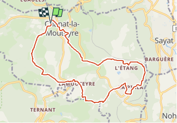
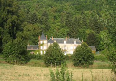
Trail Walking of 10 km to be discovered at Auvergne-Rhône-Alpes, Puy-de-Dôme, Chanat-la-Mouteyre. This trail is proposed by jagarnier.

Description

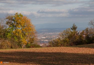
Cette randonnée vous mènera à travers les trois villages de la commune de Chanat-la-Mouteyre. Vous commencerez par un très beau panorama sur la plaine de Limagne. Vous traverserez le joli bois de Clerzat avant de découvrir l'Etang, où une harpe sculptée fait référence au jumelage de la commune avec Cappoquin, en Irlande. A Chanat, vous pourrez faire un détour pour admirer la sculpture en pierre de Volvic de Thierry Courtadon.

Elevation profile

Photos

Positioning

Country:
France
Region :
Auvergne-Rhône-Alpes
Department/Province :
Puy-de-Dôme
Municipality :
Chanat-la-Mouteyre
Location:
Unknown
Start:(UTM)
500891 ; 5075319 (31T) N.

Comments

Please log in to post a review or rate the element


Sympa mais pas exactement sur le parcours flêché.


Trails nearby

Trail Walking Durtol - Durtol_Cote_Pegnu - Photo
Walking
GUIDE
jagarnier

Walking

Easy
(1)
Durtol, Auvergne-Rhône-Alpes, Puy-de-Dôme, France
6.1 km | 9.1 km-effort
2h 0min
Yes
Trail Walking Orcines - Vulcania_Autours_Puys - Photo
Walking
GUIDE
jagarnier

Walking

Easy
(1)
Orcines, Auvergne-Rhône-Alpes, Puy-de-Dôme, France
10.7 km | 13.1 km-effort
3h 15min
Yes
Trail Walking Sayat - Sayat_Repaire_Gaulois - Photo
Walking
GUIDE
jagarnier

Walking

Easy
(1)
Sayat, Auvergne-Rhône-Alpes, Puy-de-Dôme, France
6.1 km | 9.3 km-effort
1h 59min
Yes
Trail Mountain bike Volvic - Tour du Puy de Dôme en VTT - Photo
Mountain bike
tracegps

Mountain bike

Very difficult
(1)
Volvic, Auvergne-Rhône-Alpes, Puy-de-Dôme, France
62 km | 85 km-effort
5h 30min
Yes
Trail Walking Orcines - Puy de Côme et Suchet_T - Photo
Walking
force

Walking

Medium
(1)
Orcines, Auvergne-Rhône-Alpes, Puy-de-Dôme, France
13.3 km | 21 km-effort
4h 20min
Yes
Trail Walking Orcines - Puy de Pariou - Photo
Walking
Rodolphe1508

Walking

Medium
(1)
Orcines, Auvergne-Rhône-Alpes, Puy-de-Dôme, France
8.6 km | 12.4 km-effort
3h 7min
Yes
Trail Walking Volvic - Les sources de Volvic - Photo
Walking
tracegps

Walking

Medium
(2)
Volvic, Auvergne-Rhône-Alpes, Puy-de-Dôme, France
10.9 km | 14.3 km-effort
3h 0min
Yes
Trail Walking Volvic - Egaules (près de Luzet) - Photo
Walking
tracegps

Walking

Difficult
(1)
Volvic, Auvergne-Rhône-Alpes, Puy-de-Dôme, France
8.8 km | 10.8 km-effort
2h 45min
Yes
Trail On foot Châteaugay - Les Côteaux du Plateau de Lachaud - Photo
On foot
PRO

On foot

Easy
Châteaugay, Auvergne-Rhône-Alpes, Puy-de-Dôme, France
14.2 km | 17.8 km-effort
4h 2min
Yes


Close
My subscriptions