


le gros bessillon par la stèle

bernir
User
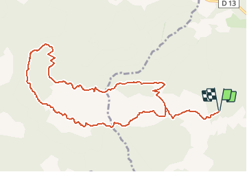

Length
12.4 km

Max alt
802 m

Uphill gradient
449 m
Km-Effort
18.4 km

Min alt
416 m

Downhill gradient
446 m
Boucle
Yes
Creation date :
2018-11-03 18:19:54.867
Updated on :
2018-11-03 18:22:49.66
3h50
Difficulty : Medium

FREE GPS app for hiking
 SityTrail
IGN / Geographical institutes
SityTrail Plus
The world is yours!
About
Trail Walking of 12.4 km to be discovered at Provence-Alpes-Côte d'Azur, Var, Cotignac. This trail is proposed by bernir.
Positioning
Country:
France
Region :
Provence-Alpes-Côte d'Azur
Department/Province :
Var
Municipality :
Cotignac
Location:
Unknown
Start:(Dec)
Start:(UTM)
267194 ; 4823908 (32T) N.
Comments