


pic-due-predouset

JACQUESD
User
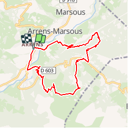

Length
9 km

Max alt
1354 m

Uphill gradient
535 m
Km-Effort
16.1 km

Min alt
861 m

Downhill gradient
534 m
Boucle
Yes
Creation date :
2018-11-07 09:35:11.494
Updated on :
2018-11-07 09:35:11.494
--
Difficulty : Unknown

FREE GPS app for hiking
 SityTrail
IGN / Geographical institutes
SityTrail Plus
The world is yours!
About
Trail Walking of 9 km to be discovered at Occitania, Hautespyrenees, Arrens-Marsous. This trail is proposed by JACQUESD.
Positioning
Country:
France
Region :
Occitania
Department/Province :
Hautespyrenees
Municipality :
Arrens-Marsous
Location:
Unknown
Start:(Dec)
Start:(UTM)
727238 ; 4759558 (30T) N.
Comments