Trail Walking Ventron - Parking Refuge des Places - Grand Ventron -Chalet Vaxelaire - Photo

Parking Refuge des Places - Grand Ventron -Chalet Vaxelaire

© OpenStreetMap contributors
Length
Length
11.2 km
Max alt
Max alt
1155 m
Uphill gradient
Uphill gradient
418 m
Km-Effort
Km-Effort  
16.8 km
Min alt
Min alt
844 m
Downhill gradient
Downhill gradient
418 m
Boucle
Boucle
Yes
Creation date :
2018-11-16 08:31:10.329
Updated on :
2018-11-16 09:22:54.555

(0 Reviews)

Walking
Walking
3h29
Difficulty : Difficult

Scan this QR Code to open this trail in the SityTrail application

FREE GPS app for hiking

Logo SityTrail SityTrail

IGN / Geographical institutes

Download SityTrail from the App Store Download SityTrail from Google Play

Logo SityTrail SityTrail Plus

The world is yours!

Download SityTrail from the App Store Download SityTrail from Google Play Download SityTrail on Huawei AppGallery

About

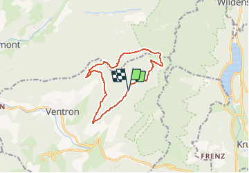
Trail Walking of 11.2 km to be discovered at Grand Est, Vosges, Ventron. This trail is proposed by patrickbeyrath.

Description

Parking Refuge des Places puis rond rouge le Grand Ventron puis triangle jaune vers la Tête du Brochet puis triangle rouge vers la Zimette et prendre triangle bleu Chalet Vaxelaire puis chevalet rouge Borne l' Orbi et retour rRefuge des Places par chevalet rouge

Elevation profile

Positioning

Country:
France
Region :
Grand Est
Department/Province :
Vosges
Municipality :
Ventron
Location:
Unknown
Start:(UTM)
343585 ; 5312676 (32T) N.


Close
My subscriptions