


Chartreuse de Vaucluse par le bord du lac

drarep
User
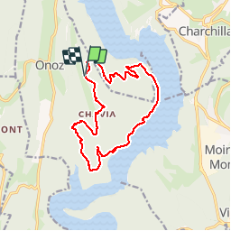

Length
14.3 km

Max alt
621 m

Uphill gradient
329 m
Km-Effort
18.7 km

Min alt
437 m

Downhill gradient
330 m
Boucle
Yes
Creation date :
2018-11-18 18:59:05.74
Updated on :
2018-12-14 22:22:52.893
4h00
Difficulty : Medium

FREE GPS app for hiking
 SityTrail
IGN / Geographical institutes
SityTrail Plus
The world is yours!
About
Trail Walking of 14.3 km to be discovered at Bourgogne-Franche-Comté, Jura, Onoz. This trail is proposed by drarep.
Positioning
Country:
France
Region :
Bourgogne-Franche-Comté
Department/Province :
Jura
Municipality :
Onoz
Location:
Unknown
Start:(Dec)
Start:(UTM)
704869 ; 5147789 (31T) N.
Comments