


![Trail Walking Crevant-Laveine - [Itinéraire] Entre Crevant et Laveine - Photo](https://media.geolcdn.com/t/1900/400/6fa182a0-77c3-4ab4-a1f7-73c600d86e47.png&format=pjpeg&maxdim=2)
[Itinéraire] Entre Crevant et Laveine

jagarnier
User GUIDE


3h00
Difficulty : Easy

FREE GPS app for hiking
 SityTrail
IGN / Geographical institutes
SityTrail Plus
The world is yours!
About
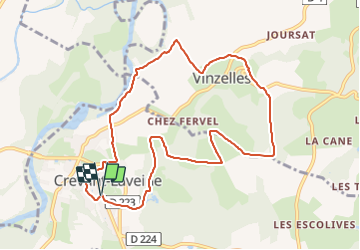
Trail Walking of 9.9 km to be discovered at Auvergne-Rhône-Alpes, Puy-de-Dôme, Crevant-Laveine. This trail is proposed by jagarnier.
Description
En bordure de l'Allier, ce petit coin, parsemé de villages tranquilles, surprend par son relief vallonné.
Dans les bois de chênes, vous pourrez rencontrer de grands rapaces et quelques vcervidés.
Photos
![Trail Walking Crevant-Laveine - [Itinéraire] Entre Crevant et Laveine - Photo 1](https://media.geolcdn.com/t/2048/auto/6fa182a0-77c3-4ab4-a1f7-73c600d86e47.png&format=jpg&maxdim=0 "Trail Walking Crevant-Laveine - [Itinéraire] Entre Crevant et Laveine - Photo 1")
Positioning
Comments