Trail Cycle Champagnole - Tram'Jurasienne - Photo
 albert39
albert39

User

© OpenStreetMap contributors
Length
Length
64 km
Max alt
Max alt
812 m
Uphill gradient
Uphill gradient
868 m
Km-Effort
Km-Effort  
76 km
Min alt
Min alt
483 m
Downhill gradient
Downhill gradient
868 m
Boucle
Boucle
Yes
Creation date :
2014-12-10 00:00:00.0
Updated on :
2014-12-10 00:00:00.0

(0 Reviews)

Cycle
Cycle
3h21
Difficulty : Medium

Scan this QR Code to open this trail in the SityTrail application

FREE GPS app for hiking

Logo SityTrail SityTrail

IGN / Geographical institutes

Download SityTrail from the App Store Download SityTrail from Google Play

Logo SityTrail SityTrail Plus

The world is yours!

Download SityTrail from the App Store Download SityTrail from Google Play Download SityTrail on Huawei AppGallery

About

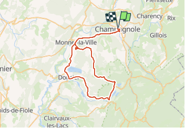
Trail Cycle of 64 km to be discovered at Bourgogne-Franche-Comté, Jura, Champagnole. This trail is proposed by albert39.

Description

Départ-Arrivée Oppidum Champagnole, Ney, Monnet la Ville, Mont sur Monnet, Saffloz, Ravito : Le Frasnois, Menetru en Joux, Songeson, Doucier, Monnet la Ville, et retour Champagnole.
Super ambiance au ravito et bouff. appréciée à l'Oppidum.  

Elevation profile

Positioning

Country:
France
Region :
Bourgogne-Franche-Comté
Department/Province :
Jura
Municipality :
Champagnole
Location:
Unknown
Start:(UTM)
722280 ; 5181203 (31T) N.


Close
My subscriptions