


Saint Laurent Cesancey Geruge Saint Laurent par la Vuard

drarep
User
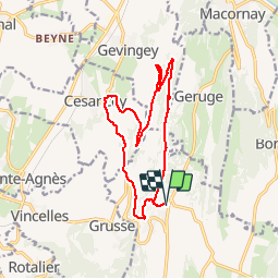

Length
14.7 km

Max alt
547 m

Uphill gradient
420 m
Km-Effort
20 km

Min alt
270 m

Downhill gradient
420 m
Boucle
Yes
Creation date :
2018-11-26 19:29:41.283
Updated on :
2018-11-26 19:40:44.056
4h17
Difficulty : Medium

FREE GPS app for hiking
 SityTrail
IGN / Geographical institutes
SityTrail Plus
The world is yours!
About
Trail Walking of 14.7 km to be discovered at Bourgogne-Franche-Comté, Jura, La Chailleuse. This trail is proposed by drarep.
Photos

Positioning
Country:
France
Region :
Bourgogne-Franche-Comté
Department/Province :
Jura
Municipality :
La Chailleuse
Location:
Saint-Laurent-la-Roche
Start:(Dec)
Start:(UTM)
692938 ; 5164088 (31T) N.
Comments