


Orgelet Plaisia par le Mt Orgier

drarep
User
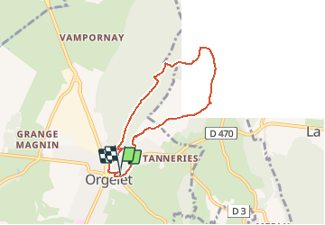

Length
6.1 km

Max alt
634 m

Uphill gradient
145 m
Km-Effort
8.1 km

Min alt
498 m

Downhill gradient
147 m
Boucle
Yes
Creation date :
2018-11-28 22:19:56.004
Updated on :
2021-11-07 10:52:39.832
1h43
Difficulty : Very easy

FREE GPS app for hiking
 SityTrail
IGN / Geographical institutes
SityTrail Plus
The world is yours!
About
Trail Walking of 6.1 km to be discovered at Bourgogne-Franche-Comté, Jura, Orgelet. This trail is proposed by drarep.
Positioning
Country:
France
Region :
Bourgogne-Franche-Comté
Department/Province :
Jura
Municipality :
Orgelet
Location:
Unknown
Start:(Dec)
Start:(UTM)
700431 ; 5155270 (31T) N.
Comments