


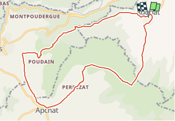
Augnat_Chaux_Caure

jagarnier
User GUIDE

Length
11.6 km

Max alt
811 m

Uphill gradient
308 m
Km-Effort
15.7 km

Min alt
584 m

Downhill gradient
307 m
Boucle
Yes
Creation date :
2018-11-30 09:39:19.65
Updated on :
2023-11-15 16:22:02.157
3h30
Difficulty : Medium

FREE GPS app for hiking
 SityTrail
IGN / Geographical institutes
SityTrail Plus
The world is yours!
About
Trail Walking of 11.6 km to be discovered at Auvergne-Rhône-Alpes, Puy-de-Dôme, Augnat. This trail is proposed by jagarnier.
Photos

Positioning
Country:
France
Region :
Auvergne-Rhône-Alpes
Department/Province :
Puy-de-Dôme
Municipality :
Augnat
Location:
Unknown
Start:(Dec)
Start:(UTM)
514178 ; 5028732 (31T) N.
Comments