PORTEL DES CORBIERES

CANON2
User
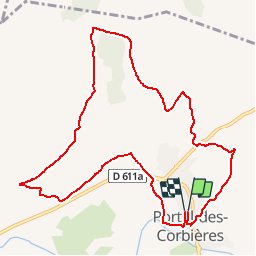

Length
11.6 km

Max alt
152 m

Uphill gradient
253 m
Km-Effort
15 km

Min alt
20 m

Downhill gradient
255 m
Boucle
Yes
Creation date :
2019-05-15 13:09:48.019
Updated on :
2019-05-15 13:09:48.074
3h14
Difficulty : Easy

FREE GPS app for hiking
 SityTrail
IGN / Geographical institutes
SityTrail Plus
The world is yours!
About
Trail Walking of 11.6 km to be discovered at Occitania, Aude, Portel-des-Corbières. This trail is proposed by CANON2.
Positioning
Country:
France
Region :
Occitania
Department/Province :
Aude
Municipality :
Portel-des-Corbières
Location:
Unknown
Start:(Dec)
Start:(UTM)
493628 ; 4767011 (31T) N.
Comments