


CLD-MM le 11/12/2018

JackPG
User
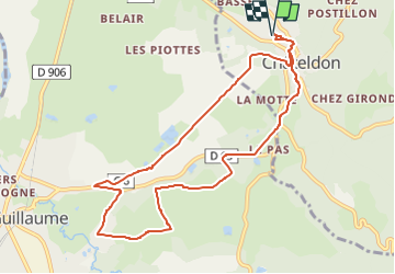

Length
9.8 km

Max alt
376 m

Uphill gradient
173 m
Km-Effort
12.1 km

Min alt
289 m

Downhill gradient
173 m
Boucle
Yes
Creation date :
2018-12-12 06:54:33.264
Updated on :
2018-12-12 07:00:23.546
2h38
Difficulty : Medium

FREE GPS app for hiking
 SityTrail
IGN / Geographical institutes
SityTrail Plus
The world is yours!
About
Trail Walking of 9.8 km to be discovered at Auvergne-Rhône-Alpes, Puy-de-Dôme, Châteldon. This trail is proposed by JackPG.
Positioning
Country:
France
Region :
Auvergne-Rhône-Alpes
Department/Province :
Puy-de-Dôme
Municipality :
Châteldon
Location:
Unknown
Start:(Dec)
Start:(UTM)
539991 ; 5091930 (31T) N.
Comments