


2012 CHALAIN

drarep
User
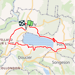

Length
17.2 km

Max alt
607 m

Uphill gradient
327 m
Km-Effort
22 km

Min alt
485 m

Downhill gradient
325 m
Boucle
Yes
Creation date :
2018-12-15 22:41:38.696
Updated on :
2019-09-13 20:25:17.5
4h39
Difficulty : Medium

FREE GPS app for hiking
 SityTrail
IGN / Geographical institutes
SityTrail Plus
The world is yours!
About
Trail Walking of 17.2 km to be discovered at Bourgogne-Franche-Comté, Jura, Marigny. This trail is proposed by drarep.
Positioning
Country:
France
Region :
Bourgogne-Franche-Comté
Department/Province :
Jura
Municipality :
Marigny
Location:
Unknown
Start:(Dec)
Start:(UTM)
712587 ; 5173224 (31T) N.
Comments