


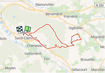
sortie vtt du 29122018 interdit

fabwin
User GUIDE


2h13
Difficulty : Medium

FREE GPS app for hiking
 SityTrail
IGN / Geographical institutes
SityTrail Plus
The world is yours!
About
Trail Mountain bike of 31 km to be discovered at Grand Est, Meurthe-et-Moselle, Saint-Clément. This trail is proposed by fabwin.
Description
Sortie VTT du jour avec David, Séb, Ange & Luca.
Quand la notion de vélo Tout Terrain prend toute sa définition, des champs, de la boue, des ruisseaux, des arbres en travers, des ronces, des clôtures, une piste d'aviation, un camp militaire.
Positioning
Comments