


2019-01-05 Marche Temple du Donon

holtzv
User GUIDE
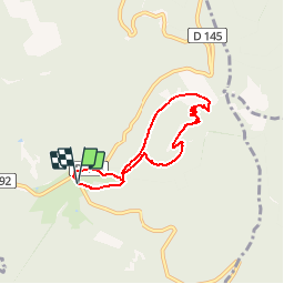

Length
5.6 km

Max alt
996 m

Uphill gradient
276 m
Km-Effort
9.3 km

Min alt
719 m

Downhill gradient
273 m
Boucle
Yes
Creation date :
2019-01-05 16:53:03.497
Updated on :
2019-01-05 16:55:26.511
1h54
Difficulty : Medium

FREE GPS app for hiking
 SityTrail
IGN / Geographical institutes
SityTrail Plus
The world is yours!
About
Trail Walking of 5.6 km to be discovered at Grand Est, Bas-Rhin, Grandfontaine. This trail is proposed by holtzv.
Description
Sous la neige
Photos


Positioning
Country:
France
Region :
Grand Est
Department/Province :
Bas-Rhin
Municipality :
Grandfontaine
Location:
Unknown
Start:(Dec)
Start:(UTM)
363163 ; 5374270 (32U) N.
Comments