


cyclo

bernir
User
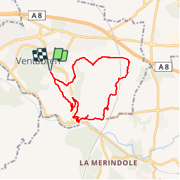

Length
14.2 km

Max alt
246 m

Uphill gradient
314 m
Km-Effort
18.4 km

Min alt
90 m

Downhill gradient
314 m
Boucle
Yes
Creation date :
2019-01-06 18:32:39.47
Updated on :
2019-01-06 19:46:31.557
--
Difficulty : Medium

FREE GPS app for hiking
 SityTrail
IGN / Geographical institutes
SityTrail Plus
The world is yours!
About
Trail On foot of 14.2 km to be discovered at Provence-Alpes-Côte d'Azur, Bouches-du-Rhône, Ventabren. This trail is proposed by bernir.
Positioning
Country:
France
Region :
Provence-Alpes-Côte d'Azur
Department/Province :
Bouches-du-Rhône
Municipality :
Ventabren
Location:
Unknown
Start:(Dec)
Start:(UTM)
685770 ; 4822802 (31T) N.
Comments