


Circuit-Corbinières-Thourie

chasle
User
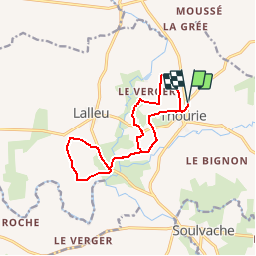

Length
12.7 km

Max alt
94 m

Uphill gradient
187 m
Km-Effort
15.2 km

Min alt
35 m

Downhill gradient
187 m
Boucle
Yes
Creation date :
2019-01-10 23:22:09.522
Updated on :
2019-01-10 23:22:09.522

FREE GPS app for hiking
 SityTrail
IGN / Geographical institutes
SityTrail Plus
The world is yours!
About
Trail of 12.7 km to be discovered at Brittany, Ille-et-Vilaine, Thourie. This trail is proposed by chasle.
Positioning
Country:
France
Region :
Brittany
Department/Province :
Ille-et-Vilaine
Municipality :
Thourie
Location:
Unknown
Start:(Dec)
Start:(UTM)
613811 ; 5301658 (30T) N.
Comments