Ceyssat_Puy_Dome

jagarnier
User GUIDE
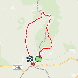

Length
7.3 km

Max alt
1416 m

Uphill gradient
380 m
Km-Effort
12.3 km

Min alt
1060 m

Downhill gradient
380 m
Boucle
Yes
Creation date :
2019-01-13 09:22:39.335
Updated on :
2024-10-06 08:05:44.538
2h15
Difficulty : Medium

FREE GPS app for hiking
 SityTrail
IGN / Geographical institutes
SityTrail Plus
The world is yours!
About
Trail Walking of 7.3 km to be discovered at Auvergne-Rhône-Alpes, Puy-de-Dôme, Orcines. This trail is proposed by jagarnier.
Photos

Positioning
Country:
France
Region :
Auvergne-Rhône-Alpes
Department/Province :
Puy-de-Dôme
Municipality :
Orcines
Location:
Unknown
Start:(Dec)
Start:(UTM)
496626 ; 5067824 (31T) N.
Comments