


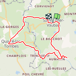
9464730-St Léger Vauban

togolo28
User

Length
18.3 km

Max alt
493 m

Uphill gradient
364 m
Km-Effort
23 km

Min alt
342 m

Downhill gradient
364 m
Boucle
Yes
Creation date :
2019-01-13 15:41:15.614
Updated on :
2019-01-13 15:51:13.146
--
Difficulty : Medium

FREE GPS app for hiking
 SityTrail
IGN / Geographical institutes
SityTrail Plus
The world is yours!
About
Trail On foot of 18.3 km to be discovered at Bourgogne-Franche-Comté, Yonne, Saint-Léger-Vauban. This trail is proposed by togolo28.
Description
Départ du village natal de Sébastien Le Prestre dit "Vauban".
Positioning
Country:
France
Region :
Bourgogne-Franche-Comté
Department/Province :
Yonne
Municipality :
Saint-Léger-Vauban
Location:
Unknown
Start:(Dec)
Start:(UTM)
579017 ; 5248546 (31T) N.
Comments