


Landévennec 2019 GM

LaurentBernard
User
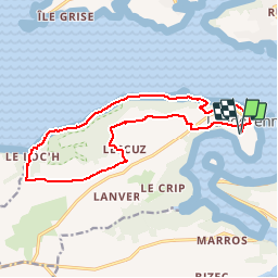

Length
15.2 km

Max alt
111 m

Uphill gradient
326 m
Km-Effort
19.5 km

Min alt
1 m

Downhill gradient
324 m
Boucle
Yes
Creation date :
2019-01-14 14:31:00.164
Updated on :
2019-01-14 14:31:43.65
--
Difficulty : Very easy

FREE GPS app for hiking
 SityTrail
IGN / Geographical institutes
SityTrail Plus
The world is yours!
About
Trail On foot of 15.2 km to be discovered at Brittany, Finistère, Landévennec. This trail is proposed by LaurentBernard.
Positioning
Country:
France
Region :
Brittany
Department/Province :
Finistère
Municipality :
Landévennec
Location:
Unknown
Start:(Dec)
Start:(UTM)
405746 ; 5349265 (30U) N.
Comments