


GR 4 (10)

chasle
User

Length
19.1 km

Max alt
736 m

Uphill gradient
403 m
Km-Effort
25 km

Min alt
475 m

Downhill gradient
480 m
Boucle
No
Creation date :
2019-01-17 21:26:58.862
Updated on :
2019-01-17 21:28:24.251
5h15
Difficulty : Very difficult

FREE GPS app for hiking
 SityTrail
IGN / Geographical institutes
SityTrail Plus
The world is yours!
About
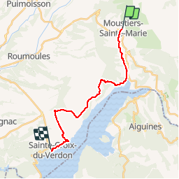
Trail Walking of 19.1 km to be discovered at Provence-Alpes-Côte d'Azur, Alpes-de-Haute-Provence, Moustiers-Sainte-Marie. This trail is proposed by chasle.
Positioning
Country:
France
Region :
Provence-Alpes-Côte d'Azur
Department/Province :
Alpes-de-Haute-Provence
Municipality :
Moustiers-Sainte-Marie
Location:
Unknown
Start:(Dec)
Start:(UTM)
276621 ; 4858520 (32T) N.
Comments