


GR 4 (12)

chasle
User

Length
20 km

Max alt
637 m

Uphill gradient
445 m
Km-Effort
27 km

Min alt
367 m

Downhill gradient
588 m
Boucle
No
Creation date :
2019-01-17 21:34:25.063
Updated on :
2019-01-17 21:35:33.794
5h38
Difficulty : Very difficult

FREE GPS app for hiking
 SityTrail
IGN / Geographical institutes
SityTrail Plus
The world is yours!
About
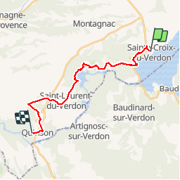
Trail Walking of 20 km to be discovered at Provence-Alpes-Côte d'Azur, Alpes-de-Haute-Provence, Sainte-Croix-du-Verdon. This trail is proposed by chasle.
Positioning
Country:
France
Region :
Provence-Alpes-Côte d'Azur
Department/Province :
Alpes-de-Haute-Provence
Municipality :
Sainte-Croix-du-Verdon
Location:
Unknown
Start:(Dec)
Start:(UTM)
270695 ; 4849113 (32T) N.
Comments