


GR 4 (16)

chasle
User

Length
21 km

Max alt
750 m

Uphill gradient
801 m
Km-Effort
31 km

Min alt
363 m

Downhill gradient
524 m
Boucle
No
Creation date :
2019-01-17 22:06:53.616
Updated on :
2019-01-17 22:07:41.423
6h36
Difficulty : Very difficult

FREE GPS app for hiking
 SityTrail
IGN / Geographical institutes
SityTrail Plus
The world is yours!
About
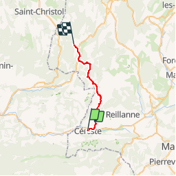
Trail Walking of 21 km to be discovered at Provence-Alpes-Côte d'Azur, Alpes-de-Haute-Provence, Céreste. This trail is proposed by chasle.
Positioning
Country:
France
Region :
Provence-Alpes-Côte d'Azur
Department/Province :
Alpes-de-Haute-Provence
Municipality :
Céreste
Location:
Unknown
Start:(Dec)
Start:(UTM)
708163 ; 4859172 (31T) N.
Comments