


GR 4 (21)

chasle
User

Length
32 km

Max alt
328 m

Uphill gradient
448 m
Km-Effort
39 km

Min alt
42 m

Downhill gradient
643 m
Boucle
No
Creation date :
2019-01-17 23:03:10.504
Updated on :
2019-01-17 23:04:00.836
8h17
Difficulty : Very difficult

FREE GPS app for hiking
 SityTrail
IGN / Geographical institutes
SityTrail Plus
The world is yours!
About
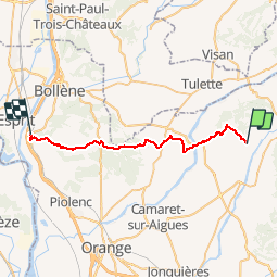
Trail Walking of 32 km to be discovered at Provence-Alpes-Côte d'Azur, Vaucluse, Rasteau. This trail is proposed by chasle.
Positioning
Country:
France
Region :
Provence-Alpes-Côte d'Azur
Department/Province :
Vaucluse
Municipality :
Rasteau
Location:
Unknown
Start:(Dec)
Start:(UTM)
658633 ; 4899485 (31T) N.
Comments