


RETORD: CRET DU NÛ

djeepee74
User

Length
10.8 km

Max alt
1351 m

Uphill gradient
306 m
Km-Effort
14.9 km

Min alt
1145 m

Downhill gradient
305 m
Boucle
Yes
Creation date :
2019-01-18 18:42:01.172
Updated on :
2019-06-28 12:48:07.182
3h15
Difficulty : Medium

FREE GPS app for hiking
 SityTrail
IGN / Geographical institutes
SityTrail Plus
The world is yours!
About
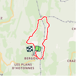
Trail Walking of 10.8 km to be discovered at Auvergne-Rhône-Alpes, Ain, Haut Valromey. This trail is proposed by djeepee74.
Description
BOUCLE
Départ: Les Bergonnes (Les Plans d'Hotonnes).
Photos


Positioning
Country:
France
Region :
Auvergne-Rhône-Alpes
Department/Province :
Ain
Municipality :
Haut Valromey
Location:
Hotonnes
Start:(Dec)
Start:(UTM)
709909 ; 5102717 (31T) N.
Comments