


RETORD: CONAY

djeepee74
User
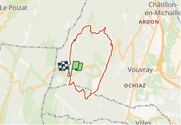

Length
12 km

Max alt
1225 m

Uphill gradient
361 m
Km-Effort
16.8 km

Min alt
1030 m

Downhill gradient
360 m
Boucle
Yes
Creation date :
2019-01-18 18:53:57.767
Updated on :
2021-03-07 19:28:44.511
3h30
Difficulty : Medium

FREE GPS app for hiking
 SityTrail
IGN / Geographical institutes
SityTrail Plus
The world is yours!
About
Trail Walking of 12 km to be discovered at Auvergne-Rhône-Alpes, Ain, Valserhône. This trail is proposed by djeepee74.
Description
BOUCLE
Positioning
Country:
France
Region :
Auvergne-Rhône-Alpes
Department/Province :
Ain
Municipality :
Valserhône
Location:
Châtillon-en-Michaille
Start:(Dec)
Start:(UTM)
711381 ; 5110033 (31T) N.
Comments