


Schächentaler Höhenweg

jschna
User
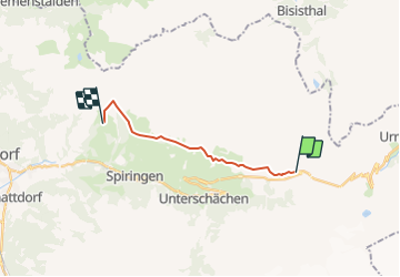

Length
11.7 km

Max alt
1874 m

Uphill gradient
449 m
Km-Effort
18.2 km

Min alt
1620 m

Downhill gradient
601 m
Boucle
No
Creation date :
2014-12-11 00:00:00.0
Updated on :
2014-12-11 00:00:00.0
--
Difficulty : Unknown

FREE GPS app for hiking
 SityTrail
IGN / Geographical institutes
SityTrail Plus
The world is yours!
About
Trail Other activity of 11.7 km to be discovered at Uri, Unknown, Unterschächen. This trail is proposed by jschna.
Description
Während 4 Stunden (reine Wanderzeit) - ein Auf-und-Ab zwischen 1600 und 1800 müM - wunderschöne Alpweiden (Flora)
Positioning
Country:
Switzerland
Region :
Uri
Department/Province :
Unknown
Municipality :
Unterschächen
Location:
Unknown
Start:(Dec)
Start:(UTM)
486875 ; 5191197 (32T) N.
Comments