


rando raquettes 20/01/19

LaurentGILG
User
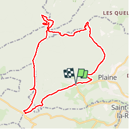

Length
20 km

Max alt
925 m

Uphill gradient
667 m
Km-Effort
29 km

Min alt
464 m

Downhill gradient
668 m
Boucle
Yes
Creation date :
2019-01-20 09:08:49.393
Updated on :
2019-01-20 19:34:23.155
7h14
Difficulty : Difficult

FREE GPS app for hiking
 SityTrail
IGN / Geographical institutes
SityTrail Plus
The world is yours!
About
Trail Walking of 20 km to be discovered at Grand Est, Bas-Rhin, Plaine. This trail is proposed by LaurentGILG.
Positioning
Country:
France
Region :
Grand Est
Department/Province :
Bas-Rhin
Municipality :
Plaine
Location:
Unknown
Start:(Dec)
Start:(UTM)
361251 ; 5364231 (32U) N.
Comments