


La St Jean - Circuit A - Fléchage Vert

VANDERPUTTENMi
User GUIDE
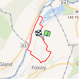

Length
5.2 km

Max alt
97 m

Uphill gradient
50 m
Km-Effort
5.8 km

Min alt
56 m

Downhill gradient
50 m
Boucle
Yes
Creation date :
2019-01-21 09:53:47.458
Updated on :
2019-06-06 19:30:29.205
1h18
Difficulty : Easy

FREE GPS app for hiking
 SityTrail
IGN / Geographical institutes
SityTrail Plus
The world is yours!
About
Trail Walking of 5.2 km to be discovered at Hauts-de-France, Aisne, Fossoy. This trail is proposed by VANDERPUTTENMi.
Description
Circuit Facile
Balisage de couleur vert
Positioning
Country:
France
Region :
Hauts-de-France
Department/Province :
Aisne
Municipality :
Fossoy
Location:
Unknown
Start:(Dec)
Start:(UTM)
535355 ; 5433988 (31U) N.
Comments