


04-Saarbrücken-Harskirchen

v.hanosset
User
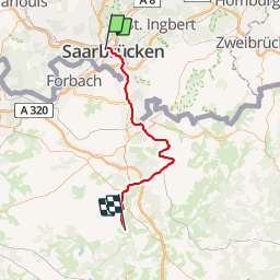

Length
53 km

Max alt
229 m

Uphill gradient
419 m
Km-Effort
58 km

Min alt
178 m

Downhill gradient
389 m
Boucle
No
Creation date :
2019-01-23 12:30:45.79
Updated on :
2019-02-13 15:34:29.679
--
Difficulty : Very easy
--
Difficulty : Very easy

FREE GPS app for hiking
 SityTrail
IGN / Geographical institutes
SityTrail Plus
The world is yours!
About
Trail Cycle of 53 km to be discovered at Saarland, Regionalverband Saarbrücken, Saarbrücken. This trail is proposed by v.hanosset.
Positioning
Country:
Germany
Region :
Saarland
Department/Province :
Regionalverband Saarbrücken
Municipality :
Saarbrücken
Location:
Bezirk Mitte
Start:(Dec)
Start:(UTM)
352741 ; 5455771 (32U) N.
Comments