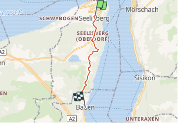
Trail Other activity Seelisberg - Bauen - Seelisberg  - Photo

Bauen - Seelisberg

 jschna
jschna

User

© OpenStreetMap contributors
Length
Length
6.1 km
Max alt
Max alt
877 m
Uphill gradient
Uphill gradient
194 m
Km-Effort
Km-Effort  
9.8 km
Min alt
Min alt
439 m
Downhill gradient
Downhill gradient
509 m
Boucle
Boucle
No
Creation date :
2014-12-11 00:00:00.0
Updated on :
2014-12-11 00:00:00.0

(0 Reviews)

Other activity
Other activity
--
Difficulty : Unknown

Scan this QR Code to open this trail in the SityTrail application

FREE GPS app for hiking

Logo SityTrail SityTrail

IGN / Geographical institutes

Download SityTrail from the App Store Download SityTrail from Google Play

Logo SityTrail SityTrail Plus

The world is yours!

Download SityTrail from the App Store Download SityTrail from Google Play Download SityTrail on Huawei AppGallery

About

Trail Other activity of 6.1 km to be discovered at Uri, Unknown, Seelisberg. This trail is proposed by jschna.

Description

Steiler Aufstieg über Treppen - ca 1 Std. - dann angenehmer Wanderweg durch Feld und Wald bis Seelisberg (2 Std 30 Min.).
Von Seelisberg kann man mit der Standseilbahn nach Treib (oder Fussweg 40 Min) dann mit dem Kursschiff nach Brunnen oder Bauen (Flüelen, je nach dem, wo Ihr Fahrzeug steht).

Elevation profile

Positioning

Country:
Switzerland
Region :
Uri
Department/Province :
Unknown
Municipality :
Seelisberg
Location:
Unknown
Start:(UTM)
468567 ; 5202922 (32T) N.


Close
My subscriptions